Mandaluyong enjoys an economically strategic location as manifested in the prime business districts just around her borders.
The city is bound on the north by the Municipality of San Juan; on the northeast by Quezon City; on the east by Pasig City; on the south and southwest by the Pasig River and Makati City; and on the west and northwest by the Pasig River and the City of Manila. (Map 1 – Mandaluyong Base Map)
A quick survey of its perimeter will show its varied urban characteristics, from low to medium density residential subdivision on the north, medium-scale commercial districts on the west, heavy industries lining its river coast on the south, and emerging commercial activities of regional scale on the east.
The physical layout of contemporary Mandaluyong is the product of historical events and growth forces.
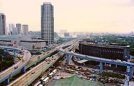
Noticeable upon entrance to the city are transportation landmarks such as the Sevilla, Lambingan, and Mandaluyong-Makati Bridges, the Guadalupe Bridge and Cloverleaf, the Pioneer Underpass, and the Ortigas Interchange.
The EDSA-Pioneer and Namayan-Vergara industrial districts traditionally served as the city’s main sources of revenue, but subsequent development in the early 80’s shifted towards the EDSA-Wack Wack and Highway Hills areas in northeast Mandaluyong.